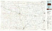
1985 Map of Medicine Lodge
USGS Topo · Published 1985About this map
Medicine Lodge serves as the regional hub for this mid-1980s landscape, where the Medicine Lodge River carves a winding path through Barber County. The map documents a rural infrastructure defined by extensive rail networks, including the Atchison Topeka and Santa Fe and the Missouri Pacific lines that connect smaller prairie settlements like Attica and Sharon. A notable historical trace is the Old Indian Treaty Boundary, which cuts across the northern township lines, a reminder of nineteenth-century land partitions surviving into modern cartography.
Find a feature on this map
95 named features on this map. Tap any name to fly to it.
Don’t see what you’re looking for? This feature index may not catch every label — zoom into the map to look around manually.
Map Details
Editions of this 1985 Medicine Lodge Map
2 editions found
Other maps of this area

1889 · Anthony
USGS Topo · 1:125,000

1889 · Cheney
USGS Topo · 1:125,000

1889 · Caldwell
USGS Topo · 1:125,000

1889 · Kinsley
USGS Topo · 1:125,000

1891 · Medicine Lodge
USGS Topo · 1:125,000

1891 · Cheney
USGS Topo · 1:125,000

1891 · Anthony
USGS Topo · 1:125,000

1892 · Kinsley
USGS Topo · 1:125,000

1892 · Kingman
USGS Topo · 1:125,000

1892 · Coldwater
USGS Topo · 1:125,000