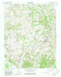
1959 Map of Medina
USGS Topo · Published 1981About this map
Medina serves as a central hub on this West Tennessee landscape, situated along the Illinois Central Gulf rail line. The map captures a detailed transition of the rural economy, where small agrarian settlements like Goat City and Sitka are connected by a network of named country roads such as Graball Road and Mullins Road. Along the eastern edge, the massive Milan Arsenal military reservation introduces a significant federal presence near the Gibson and Madison county line.
Find a feature on this map
43 named features on this map. Tap any name to fly to it.
Don’t see what you’re looking for? This feature index may not catch every label — zoom into the map to look around manually.
Map Details
Editions of this 1959 Medina Map
4 editions found
Other maps of this area

1950 · Jackson North
USGS Topo · 1:24,000

1951 · Jackson North
USGS Topo · 1:24,000

1951 · Trenton
USGS Topo · 1:24,000

1952 · Milan
USGS Topo · 1:24,000

1953 · Claybrook
USGS Topo · 1:24,000

1956 · Blytheville
USGS Topo · 1:250,000

1959 · Medina
USGS Topo · 1:24,000

1959 · Blytheville
USGS Topo · 1:250,000

1959 · Adair
USGS Topo · 1:24,000

1959 · Humboldt
USGS Topo · 1:24,000