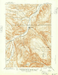
1913 Map of Meeteetse
USGS Topo · Published 1949About this map
The Greybull River valley serves as the central artery of this early 20th-century Wyoming landscape, where the town of Meeteetse is positioned at a critical junction of water and travel routes. Surveyed in 1911, the map captures a period of ranching and early resource extraction, highlighted by the Black Diamond Mine north of the river. The topography is defined by significant elevation changes, from the prominent Meeteetse Rim to the depression known as Hole in the Ground.
Find a feature on this map
24 named features on this map. Tap any name to fly to it.
Don’t see what you’re looking for? This feature index may not catch every label — zoom into the map to look around manually.
Map Details
Editions of this 1913 Meeteetse Map
3 editions found
Other maps of this area

1904 · Kirwin
USGS Topo · 1:125,000

1906 · Kirwin
USGS Topo · 1:125,000

1911 · Meeteetse
USGS Topo · 1:62,500

1911 · Oregon Basin
USGS Topo · 1:62,500

1913 · Oregon Basin
USGS Topo · 1:62,500

1913 · Meeteetse
USGS Topo · 1:62,500

1913 · Grass Creek Basin
USGS Topo · 1:62,500

1915 · Grass Creek Basin
USGS Topo · 1:62,500

1951 · Hillberry Rim
USGS Topo · 1:24,000

1951 · Sheets Flat
USGS Topo · 1:24,000