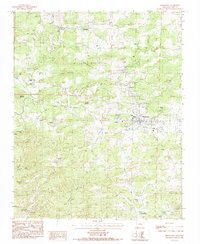
1984 Map of Melbourne
USGS Topo · Published 1984About this map
Melbourne serves as the focal point of this Izard County landscape, situated where the terrain transitions from the heights of Brushy Ridge and Bald Mountain toward the winding waterways of Rocky Bayou. The 1984 survey captures the community just as the Ozarka Vo-Tech Sch was establishing its presence on the eastern edge of town. Surrounding the municipal center, the map identifies numerous family and community landmarks, including Bigham Cem and Combs Cem, which offer significant value for genealogical research. The rural character is further defined by scattered settlements like Newburg and Lunenburg, connected by the early infrastructure of the Wooden Pole Trans Line. Natural features such as the Melbourne Cave and the headwaters of Hurricane Creek highlight the geological diversity of this Ozark foothills region during the early 1980s.
Find a feature on this map
36 named features on this map. Tap any name to fly to it.
Don’t see what you’re looking for? This feature index may not catch every label — zoom into the map to look around manually.
Map Details
Editions of this 1984 Melbourne Map
This is the sole edition of this map. No revisions or reprints were ever made.
Other maps of this area

1890 · Batesville
USGS Topo · 1:125,000

1890 · Mountain Home
USGS Topo · 1:125,000

1891 · Mountain Home
USGS Topo · 1:125,000

1891 · Batesville
USGS Topo · 1:125,000

1892 · Mountain View
USGS Topo · 1:125,000

1894 · Mountain View
USGS Topo · 1:125,000

1894 · Mountain Home
USGS Topo · 1:125,000

1942 · Mt Pleasant
USGS Topo · 1:31,680

1945 · Harrison
USGS Topo · 1:250,000

1949 · Harrison
USGS Topo · 1:250,000