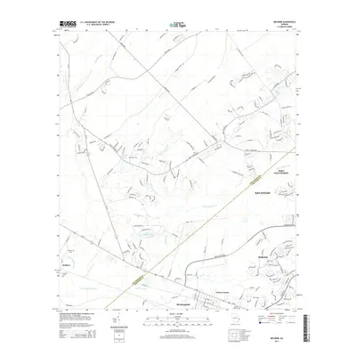
2014 Map of Meldrim
USGS Topo · Published 2014About this map
The boundary between Effingham and Chatham Counties cuts diagonally across this coastal plain landscape west of Savannah. Small settlements and residential enclaves like Meldrim, Bloomingdale, and Ottawa Estates anchor the southern portion of the area, while the northern reaches remain defined by a network of creeks and wetlands. Several historic family and community burial sites, including Hester Cem, Meldrim Cem, and Old Hill Cem, are preserved here, offering valuable reference points for genealogical research. The drainage patterns of the Little Ogeechee River and the Hardin Canal illustrate the hydrological management of the region, where water bodies like Zeigler Pond and the interestingly named River Styx thread through the low-lying terrain. This document shows the suburban transition between the inland pine forests and the expanding outskirts of Pooler and Port Wentworth.
Find a feature on this map
164 named features on this map. Tap any name to fly to it.
Don’t see what you’re looking for? This feature index may not catch every label — zoom into the map to look around manually.
Map Details
Editions of this 2014 Meldrim Map
This is the sole edition of this map. No revisions or reprints were ever made.
Other maps of this area

1919 · Egypt
USGS Topo · 1:62,500

1920 · Hardeeville
USGS Topo · 1:62,500

1920 · Meldrim
USGS Topo · 1:62,500

1939 · Egypt
USGS Topo · 1:62,500

1942 · Meldrim
USGS Topo · 1:62,500

1942 · Savannah
USGS Topo · 1:62,500

1943 · Hardeeville
USGS Topo · 1:62,500

1943 · Egypt
USGS Topo · 1:62,500

1947 · Savannah
USGS Topo · 1:250,000

1948 · Savannah
USGS Topo · 1:250,000