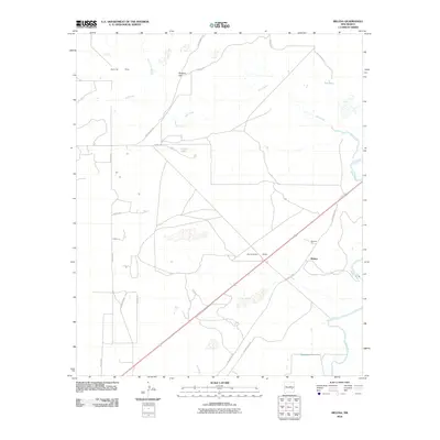
2010 Map of Melena
USGS Topo · Published 2010About this map
The Pecos River snakes through the eastern edge of this Chaves County landscape, providing a sharp contrast to the arid expanses of Garcia Flat and the rising elevations of the Dunnahoo Hills. In the early 21st century, this region south of Roswell is characterized by its wide-reaching drainage networks, including Salt Creek and the Arroyo del Macho. The small settlement at Melena sits near the junction of several critical transport routes, notably the Old Clovis Hwy and Bitter Lakes Rd, which intersect the central plains. Local resource extraction and water management are evident at Beavers Pit and Lowe Lake, while landmarks like Ballard Hill and the uniquely named Ink Pots punctuate the northern terrain. This survey provides a clear view of the ranching and agricultural grid, defined by named corridors like Cottonwood Rd and Capitan Ave.
Find a feature on this map
23 named features on this map. Tap any name to fly to it.
Don’t see what you’re looking for? This feature index may not catch every label — zoom into the map to look around manually.
Map Details
Editions of this 2010 Melena Map
This is the sole edition of this map. No revisions or reprints were ever made.
Other maps of this area

1949 · Roswell North
USGS Topo · 1:24,000

1950 · Comanche Spring
USGS Topo · 1:24,000

1950 · Bitter Lake
USGS Topo · 1:24,000

1955 · Roswell
USGS Topo · 1:250,000

1958 · Roswell
USGS Topo · 1:250,000

1962 · Roswell
USGS Topo · 1:250,000
1962 · Roswell North
USGS Topo · 1:24,000

1962 · Eightmile Draw
USGS Topo · 1:24,000
1962 · Bitter Lake
USGS Topo · 1:24,000

1962 · Panther Hill
USGS Topo · 1:24,000