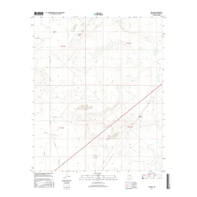
2017 Map of Melena
USGS Topo · Published 2017About this map
The Melena settlement sits at the heart of this Chaves County landscape, positioned along a transportation corridor that intersects the arid plains of eastern New Mexico. The terrain is defined by a complex drainage system where Salt Creek and the Arroyo del Macho feed into the prominent Pecos River. This map reveals a specialized environment of ephemeral and permanent water features, most notably the Ink Pots and Skull Lake, which suggest localized depressions or sinkholes common to the karst topography of the Pecos Valley. The human footprint is marked by a grid of rural roads such as Capitan Rd and Co Rd 51, supporting the ranching and livestock operations that have long characterized Garcia Flat. Geographers can trace the course of the Lost River as it navigates the low-lying areas near the southern boundary of this 2017 study.
Find a feature on this map
27 named features on this map. Tap any name to fly to it.
Don’t see what you’re looking for? This feature index may not catch every label — zoom into the map to look around manually.
Map Details
Editions of this 2017 Melena Map
This is the sole edition of this map. No revisions or reprints were ever made.
Other maps of this area

1949 · Roswell North
USGS Topo · 1:24,000

1950 · Comanche Spring
USGS Topo · 1:24,000

1950 · Bitter Lake
USGS Topo · 1:24,000

1955 · Roswell
USGS Topo · 1:250,000

1958 · Roswell
USGS Topo · 1:250,000

1962 · Roswell
USGS Topo · 1:250,000
1962 · Roswell North
USGS Topo · 1:24,000

1962 · Eightmile Draw
USGS Topo · 1:24,000
1962 · Bitter Lake
USGS Topo · 1:24,000

1962 · Panther Hill
USGS Topo · 1:24,000