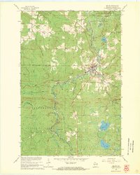
1967 Map of Mellen
USGS Topo · Published 1969About this map
Mellen serves as the central hub of this late-1960s Wisconsin landscape, situated at the confluence of the Bad River and the Montreal River. The town's industrial and logistical identity is defined by the Soo Line railroad, which cuts through the rugged northern terrain past several local operations, including a Sandpit and Quarry. To the north, Copper Falls State Park preserves the dramatic topography where the Bad River meets Tyler Forks, while the expansive Chequamegon National Forest dominates the southwestern quadrant. Smaller communities and junctions like Foster Junction and Cayuga appear alongside family-named landmarks and water bodies such as Meder Lake and Loon Lake, illustrating the post-war balance of resource extraction and growing recreational use in Ashland County.
Find a feature on this map
39 named features on this map. Tap any name to fly to it.
Don’t see what you’re looking for? This feature index may not catch every label — zoom into the map to look around manually.
Map Details
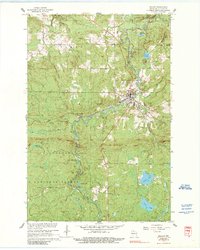
Editions of this 1967 Mellen Map
2 editions found
Other maps of this area

1942 · Glidden
USGS Topo · 1:48,000

1942 · Clam Lake
USGS Topo · 1:48,000

1942 · Mellen
USGS Topo · 1:48,000

1942 · Marengo
USGS Topo · 1:48,000

1945 · Marengo
USGS Topo · 1:48,000

1945 · Clam Lake
USGS Topo · 1:48,000

1945 · Glidden
USGS Topo · 1:48,000

1945 · Mellen
USGS Topo · 1:48,000

1953 · Ashland
USGS Topo · 1:250,000
1956 · Mt. Whittlesey
USGS Topo · 1:24,000