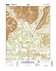
2016 Map of Melozitna D-3 NW
USGS Topo · Published 2016About this map
The Koyukuk River dominates this interior Alaska landscape, weaving a complex network of braids and bypasses through the Melozitna region. The hydrology of the area is defined by the heavy silt and seasonal shifts of the river, which has carved out features like Mathews Slough and the prominent Rock Island Point. This 2016 survey illustrates the dynamic nature of the river valley, where the main channel is fed by tributaries including the Batza River, Pocahontas Creek, and the Indian River. While the lowlands are a maze of wetlands and seasonal watercourses, the surrounding topography rises sharply into the uplands of the Yukon-Koyukuk region, providing a clear view of the boundary between the active floodplain and the interior highlands.
Find a feature on this map
11 named features on this map. Tap any name to fly to it.
Don’t see what you’re looking for? This feature index may not catch every label — zoom into the map to look around manually.
Map Details
Editions of this 2016 Melozitna D-3 NW Map
This is the sole edition of this map. No revisions or reprints were ever made.
Other maps of this area

1951 · Hughes
USGS Topo · 1:250,000

1951 · Melozitna
USGS Topo · 1:250,000

1952 · Melozitna D-3
USGS Topo · 1:63,360

1954 · Melozitna D-4
USGS Topo · 1:63,360

1954 · Melozitna D-3
USGS Topo · 1:63,360

1955 · Hughes A-3
USGS Topo · 1:63,360

1956 · Hughes
USGS Topo · 1:250,000

1956 · Melozitna
USGS Topo · 1:250,000
1956 · Hughes A-3
USGS Topo · 1:63,360

1964 · Hughes
USGS Topo · 1:250,000