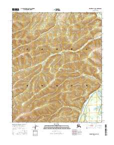
2016 Map of Melozitna D-4 NE
USGS Topo · Published 2016About this map
The Koyukuk River winds through the southeastern corner of this Interior Alaska landscape, serving as the dominant geographic feature in an area defined by its complex drainage systems. This 2016 survey illustrates the braided nature of the river's path as it interacts with the surrounding lowlands. In the far northeast, the Batza River makes a brief appearance, contributing to the network of waterways that define the Yukon-Koyukuk region. The map provides a clear look at the Public Land Survey System grid, including boundaries for t7n r20e and t6n r21e, which organize this largely undeveloped terrain. The relief shading and contour lines reveal a series of ridges and valleys that dictate the flow of smaller, unnamed seasonal streams toward the primary river basins.
Find a feature on this map
6 named features on this map. Tap any name to fly to it.
Don’t see what you’re looking for? This feature index may not catch every label — zoom into the map to look around manually.
Map Details
Editions of this 2016 Melozitna D-4 NE Map
This is the sole edition of this map. No revisions or reprints were ever made.
Other maps of this area

1951 · Hughes
USGS Topo · 1:250,000

1951 · Melozitna
USGS Topo · 1:250,000

1952 · Melozitna D-3
USGS Topo · 1:63,360

1954 · Melozitna D-4
USGS Topo · 1:63,360

1954 · Melozitna D-3
USGS Topo · 1:63,360

1955 · Hughes A-3
USGS Topo · 1:63,360

1956 · Hughes
USGS Topo · 1:250,000

1956 · Melozitna
USGS Topo · 1:250,000
1956 · Hughes A-3
USGS Topo · 1:63,360

1964 · Hughes
USGS Topo · 1:250,000