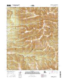
2016 Map of Melozitna D-4 NW
USGS Topo · Published 2016About this map
Hot Springs Cr winds through the southern reaches of this interior Alaska terrain, flowing past the geothermal features that give the waterway its name. The landscape is defined by the high elevations of the Isahuitila Mountains and the prominent Deniktaw Ridge, which separates the drainage basins of the region. This 2016 survey highlights the sparse, remote nature of the Yukon-Koyukuk region, where the absence of roads or permanent settlements underscores a wilderness dominated by topographical extremes. Geologists and environmental researchers can trace the course of Bauthabidlawt Cr as it cuts through the northern valleys, providing a precise record of the hydrologic patterns and mountain crests that have shaped this portion of the Melozitna area for generations.
Find a feature on this map
2 named features on this map. Tap any name to fly to it.
Don’t see what you’re looking for? This feature index may not catch every label — zoom into the map to look around manually.
Map Details
Editions of this 2016 Melozitna D-4 NW Map
This is the sole edition of this map. No revisions or reprints were ever made.
Other maps of this area

1951 · Hughes
USGS Topo · 1:250,000

1951 · Melozitna
USGS Topo · 1:250,000

1954 · Melozitna D-5
USGS Topo · 1:63,360

1954 · Melozitna D-4
USGS Topo · 1:63,360

1956 · Hughes
USGS Topo · 1:250,000

1956 · Melozitna
USGS Topo · 1:250,000

1964 · Hughes
USGS Topo · 1:250,000

1965 · Hughes
USGS Topo · 1:250,000
1986 · Hughes A-5
USGS Topo · 1:63,360
1986 · Hughes A-4
USGS Topo · 1:63,360