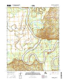
2016 Map of Melozitna D-5 NW
USGS Topo · Published 2016About this map
The Koyukuk River dominates this interior Alaska landscape, winding in broad, rhythmic meanders that define the local geography. These massive oxbows and river bends reveal a dynamic hydrological environment where the water constantly reshapes the surrounding terrain. Near the northern edge of the sheet, the Hogatza River flows into this drainage system, contributing to the complex network of wetlands and seasonal channels. A singular topographic landmark, Winthrop Point, rises above the river valley in the northwest, offering a rare point of elevation in a region otherwise characterized by shifting alluvial plains. The map provides a detailed view of the Public Land Survey System divisions, including t7n r16e and t6n r17e, illustrating how this remote territory is partitioned for administrative and land-use purposes.
Find a feature on this map
7 named features on this map. Tap any name to fly to it.
Don’t see what you’re looking for? This feature index may not catch every label — zoom into the map to look around manually.
Map Details
Editions of this 2016 Melozitna D-5 NW Map
This is the sole edition of this map. No revisions or reprints were ever made.
Other maps of this area

1951 · Hughes
USGS Topo · 1:250,000

1951 · Melozitna
USGS Topo · 1:250,000

1954 · Melozitna D-5
USGS Topo · 1:63,360

1954 · Melozitna D-6
USGS Topo · 1:63,360

1956 · Hughes
USGS Topo · 1:250,000

1956 · Melozitna
USGS Topo · 1:250,000

1964 · Hughes
USGS Topo · 1:250,000

1965 · Hughes
USGS Topo · 1:250,000
1986 · Hughes A-6
USGS Topo · 1:63,360
1986 · Hughes A-5
USGS Topo · 1:63,360