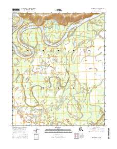
2016 Map of Melozitna D-6 NE
USGS Topo · Published 2016About this map
The Koyukuk River dominates this interior landscape, winding in broad, serpentine meanders through the Yukon-Koyukuk region. In the northern reaches of the sheet, the river is pinched between rising terrain to the north and low-lying alluvial plains to the south. Winthrop Point serves as a prominent landmark on the northern bank, marking a sharp bend in the river's course. The surrounding area is characterized by an intricate network of sloughs and wetlands, illustrating the shifting nature of the river over time as it cuts new channels and leaves behind abandoned oxbows across the valley floor.
Find a feature on this map
6 named features on this map. Tap any name to fly to it.
Don’t see what you’re looking for? This feature index may not catch every label — zoom into the map to look around manually.
Map Details
Editions of this 2016 Melozitna D-6 NE Map
This is the sole edition of this map. No revisions or reprints were ever made.
Other maps of this area

1951 · Hughes
USGS Topo · 1:250,000

1951 · Melozitna
USGS Topo · 1:250,000

1954 · Melozitna D-5
USGS Topo · 1:63,360

1954 · Melozitna D-6
USGS Topo · 1:63,360

1956 · Hughes
USGS Topo · 1:250,000

1956 · Melozitna
USGS Topo · 1:250,000

1964 · Hughes
USGS Topo · 1:250,000

1965 · Hughes
USGS Topo · 1:250,000
1986 · Hughes A-6
USGS Topo · 1:63,360
1986 · Hughes A-5
USGS Topo · 1:63,360