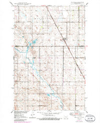
1950 Map of Melville
USGS Topo · Published 1986About this map
Melville and the surrounding prairie of Foster and Stutsman Counties are defined by a rhythmic grid of rural schoolhouses and the winding course of Pipestem Creek. This mid-century landscape, based on 1940s aerial photography and 1980s revisions, reveals the dispersed nature of settlement across the Melville, Walters, Bordulac, and Glacier townships. The Burlington Northern railroad cuts a diagonal line through the northern half of the map, passing directly through the community of Melville. A series of numbered educational landmarks, including School No 31, School No 1, and School No 2, are situated at regular intervals, serving as the social anchors for the agricultural families of the Missouri River Basin. The presence of Lake Bonita and the creek's seasonal wetlands provides a distinct contrast to the surrounding grain fields and township roads.
Find a feature on this map
14 named features on this map. Tap any name to fly to it.
Don’t see what you’re looking for? This feature index may not catch every label — zoom into the map to look around manually.
Map Details
Editions of this 1950 Melville Map
2 editions found
Other maps of this area

1900 · Pingree
USGS Topo · 1:125,000

1900 · Pingree
USGS Topo · 1:62,500

1948 · Carrington
USGS Topo · 1:62,500

1950 · Carrington East
USGS Topo · 1:24,000

1950 · Melville
USGS Topo · 1:24,000

1950 · Carrington SW
USGS Topo · 1:24,000

1950 · Carrington West
USGS Topo · 1:24,000

1951 · Pingree
USGS Topo · 1:24,000

1951 · Bordulac SW
USGS Topo · 1:24,000
1951 · Bordulac
USGS Topo · 1:24,000