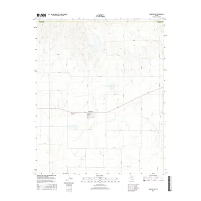
2016 Map of Memphis NW
USGS Topo · Published 2016About this map
Lakeview serves as the primary hub of activity in this part of the Texas Panhandle, situated along the border of Donley Co and Hall Co. The street grid of the town is remarkably well-defined, featuring thoroughfares such as Shoe Bar St, Davenport St, and Main St. Local history and genealogy are centered around the Lakeview Cem located just west of the town center. The landscape is defined by the drainage systems of Oaks Cr and Spring Cr, which move through the ranch land and agricultural fields. Notable water management features include the Soil Conservation Service Site 15 Reservoir and the Deaver Springs, illustrating the region's reliance on managed water resources in an arid environment. The map also shows a complex network of farm-to-market roads like FM 3517 and FM 2472, which connect the scattered rural homesteads to the central settlement.
Find a feature on this map
30 named features on this map. Tap any name to fly to it.
Don’t see what you’re looking for? This feature index may not catch every label — zoom into the map to look around manually.
Map Details
Editions of this 2016 Memphis NW Map
This is the sole edition of this map. No revisions or reprints were ever made.
Other maps of this area

1954 · Plainview
USGS Topo · 1:250,000

1958 · Plainview
USGS Topo · 1:250,000

1960 · Brice
USGS Topo · 1:62,500

1961 · Memphis
USGS Topo · 1:62,500

1963 · Hedley
USGS Topo · 1:24,000

1963 · Clarendon SE
USGS Topo · 1:24,000

1963 · Giles
USGS Topo · 1:24,000

1976 · Brice SE
USGS Topo · 1:24,000

1976 · Memphis NW
USGS Topo · 1:24,000
1976 · Brice NE
USGS Topo · 1:24,000