
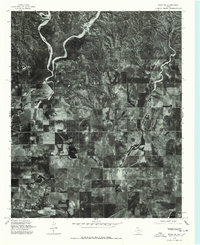
1976 Map of Memphis NW
USGS Topo · Published 1978About this map
Lakeview serves as the central focal point of this 1976 orthophotoquad, where the rigid geometry of the West Texas agricultural grid meets the natural winding course of Oaks Creek. The aerial imagery reveals a landscape defined by intensive land management, showing a complex pattern of terraced fields designed for moisture retention in the dry Panhandle climate. These contour-plowed fields are punctuated by deep, brushy drainages and arroyos that feed into the central creek bed, illustrating the local struggle with soil erosion and water runoff. The small settlement of Lakeview appears as a compact cluster of structures along the primary east-west corridor of Route 256, providing a clear record of the town's footprint and local rural infrastructure in the mid-1970s before modern consolidation changed many small Texas farming communities.
Find a feature on this map
3 named features on this map. Tap any name to fly to it.
Don’t see what you’re looking for? This feature index may not catch every label — zoom into the map to look around manually.
Map Details
Editions of this 1976 Memphis NW Map
This is the sole edition of this map. No revisions or reprints were ever made.
Other maps of this area

1954 · Plainview
USGS Topo · 1:250,000

1958 · Plainview
USGS Topo · 1:250,000

1960 · Brice
USGS Topo · 1:62,500

1961 · Memphis
USGS Topo · 1:62,500

1963 · Hedley
USGS Topo · 1:24,000

1963 · Clarendon SE
USGS Topo · 1:24,000

1963 · Giles
USGS Topo · 1:24,000

1976 · Brice SE
USGS Topo · 1:24,000
1976 · Brice NE
USGS Topo · 1:24,000

1976 · Memphis SE
USGS Topo · 1:24,000