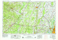
1953 Map of Memphis
USGS Topo · Published 1979About this map
The Mississippi River valley and the rising elevations of Crowleys Ridge define this mid-century landscape where Tennessee, Arkansas, and Mississippi meet. Centered on the sprawling urban center of Memphis and its cross-river neighbor West Memphis, the map reveals a region defined by extensive river systems and drainage projects, including the St. Francis River and Cache River. On the Arkansas side, the rise of Jonesboro and the river port of Newport anchor the agricultural plains, while the eastern edge of the Ozark Mountains begins to emerge in the northwest near Batesville.
Find a feature on this map
261 named features on this map. Tap any name to fly to it.
Don’t see what you’re looking for? This feature index may not catch every label — zoom into the map to look around manually.
Map Details
Editions of this 1953 Memphis Map
3 editions found

Other maps of this area

1890 · Batesville
USGS Topo · 1:125,000

1890 · Mountain Home
USGS Topo · 1:125,000

1891 · Little Rock
USGS Topo · 1:125,000

1891 · Mountain Home
USGS Topo · 1:125,000

1891 · Batesville
USGS Topo · 1:125,000

1892 · Mountain View
USGS Topo · 1:125,000

1893 · Little Rock
USGS Topo · 1:125,000

1894 · Mountain View
USGS Topo · 1:125,000

1894 · Mountain Home
USGS Topo · 1:125,000

1908 · Lake Cormorant
USGS Topo · 1:24,000