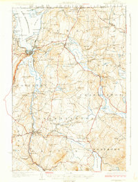
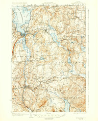
1925 Map of Memphremagog
USGS Topo · Published 1925About this map
The international border between Canada and the United States defines the northern edge of this Orleans County landscape, where the waters of Lake Memphremagog and the Clyde River shaped early 20th-century life. The city of Newport serves as a hub for the Boston and Maine RR, which follows the shoreline of South Bay and connects the region's agricultural and industrial centers. Local industry is anchored by the Willey Granite Quarry in Derby, while the network of one-room schoolhouses like North Neighborhood School and Nelson Hill School speaks to a decentralized rural population in the 1920s.
Find a feature on this map
114 named features on this map. Tap any name to fly to it.
Don’t see what you’re looking for? This feature index may not catch every label — zoom into the map to look around manually.
Map Details
Editions of this 1925 Memphremagog Map
4 editions found

Other maps of this area

1919 · Lake Memphremagog
USGS Topo · 1:62,500

1920 · Derby
USGS Topo · 1:62,500

1920 · Irasburg
USGS Topo · 1:62,500

1923 · Irasburg
USGS Topo · 1:48,000

1923 · Lake Memphremagog
USGS Topo · 1:48,000

1924 · Island Pond
USGS Topo · 1:48,000

1925 · Irasburg
USGS Topo · 1:62,500

1925 · Memphremagog
USGS Topo · 1:62,500

1926 · Island Pond
USGS Topo · 1:62,500

1928 · Hardwick
USGS Topo · 1:62,500