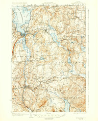
1925 Map of Memphremagog
USGS Topo · Published 1936About this map
Lake Memphremagog dominates the northwestern corner of this northern Vermont landscape, serving as a focal point for international transit and commerce in the 1920s. Along its shores, the Steamboat Route and rail lines like the Boston and Maine RR and Canadian Pacific Ry converge at Newport, which was then a bustling hub of lake-and-rail activity. To the south, the deep waters of Lake Willoughby are framed by May Pond Mtn, while the interior of Orleans County is dotted with one-room schoolhouses like Merrill Hill School and Kittredge School, serving small upland farming communities.
Find a feature on this map
116 named features on this map. Tap any name to fly to it.
Don’t see what you’re looking for? This feature index may not catch every label — zoom into the map to look around manually.
Map Details
Editions of this 1925 Memphremagog Map
4 editions found
Other maps of this area

1919 · Lake Memphremagog
USGS Topo · 1:62,500

1920 · Derby
USGS Topo · 1:62,500

1920 · Irasburg
USGS Topo · 1:62,500

1923 · Irasburg
USGS Topo · 1:48,000

1923 · Lake Memphremagog
USGS Topo · 1:48,000

1924 · Island Pond
USGS Topo · 1:48,000

1925 · Irasburg
USGS Topo · 1:62,500

1925 · Memphremagog
USGS Topo · 1:62,500

1926 · Island Pond
USGS Topo · 1:62,500

1928 · Hardwick
USGS Topo · 1:62,500