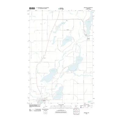
2010 Map of Menahga
USGS Topo · Published 2010About this map
Menahga serves as the primary hub at the southern edge of this Wadena County landscape, situated where the Blueberry River meets Spirit Lake. The topography is defined by an intricate network of waterways, including the Shell River, which winds past the small settlement of Horton toward Blueberry Lake and the Twin Lakes. This 2010 survey illustrates a region where glacial lakes and narrow river corridors dictate the layout of rural roads and land use. To the northeast, the village of Hubbard sits near the southern tip of Long Lake, where the Long Lake Dam regulates the water level. The presence of Falk Airport and the Fair Havens Golf Course indicates a mix of local infrastructure and recreational development integrated into the traditional lake-and-river geography of central Minnesota. Significant water bodies like Stocking Lake, Hinds Lake, and Lord Lake are connected by creeks such as Stocking Creek, forming a complex drainage pattern that has shaped local settlement for generations.
Find a feature on this map
57 named features on this map. Tap any name to fly to it.
Don’t see what you’re looking for? This feature index may not catch every label — zoom into the map to look around manually.
Map Details
Editions of this 2010 Menahga Map
This is the sole edition of this map. No revisions or reprints were ever made.
Other maps of this area

1953 · Brainerd
USGS Topo · 1:250,000

1957 · Brainerd
USGS Topo · 1:250,000

1958 · Brainerd
USGS Topo · 1:250,000

1965 · Brainerd
USGS Topo · 1:250,000

1969 · Park Rapids
USGS Topo · 1:24,000

1969 · Menahga
USGS Topo · 1:24,000

1969 · Park Rapids SW
USGS Topo · 1:24,000

1969 · Sebeka
USGS Topo · 1:24,000

1969 · Sebeka NW
USGS Topo · 1:24,000
1969 · Park Rapids NW
USGS Topo · 1:24,000