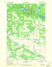
1969 Map of Park Rapids NW
USGS Topo · Published 1971About this map
Two Inlets State Forest dominates the northern reaches of this landscape, where a dense network of glacial basins and wetlands defines the geography. The terrain is notably water-heavy, featuring numerous named bodies including Beden Lake, Portage Lake, and Sloan Lake. To the south, the meandering Straight River and Shell River wind through the township of Green Valley, showing the natural drainage patterns of the region before significant modern development. Cultural markers are sparse but significant for local history, such as the Crandall Cem and a small Gravel Pit near Straight Lake. The transition between Osage and Todd townships is clearly delineated, illustrating the rural character of the Becker and Hubbard county line during the late 1960s. This survey is particularly useful for observing the original water levels and forest boundaries within the Two Inlets area.
Find a feature on this map
20 named features on this map. Tap any name to fly to it.
Don’t see what you’re looking for? This feature index may not catch every label — zoom into the map to look around manually.
Map Details
Editions of this 1969 Park Rapids NW Map
This is the sole edition of this map. No revisions or reprints were ever made.
Other maps of this area

1953 · Brainerd
USGS Topo · 1:250,000

1954 · Bemidji
USGS Topo · 1:250,000

1957 · Brainerd
USGS Topo · 1:250,000

1957 · Bemidji
USGS Topo · 1:250,000

1958 · Bemidji
USGS Topo · 1:250,000

1958 · Brainerd
USGS Topo · 1:250,000

1965 · Brainerd
USGS Topo · 1:250,000

1969 · Wolf Lake
USGS Topo · 1:24,000

1969 · Park Rapids
USGS Topo · 1:24,000

1969 · Menahga
USGS Topo · 1:24,000