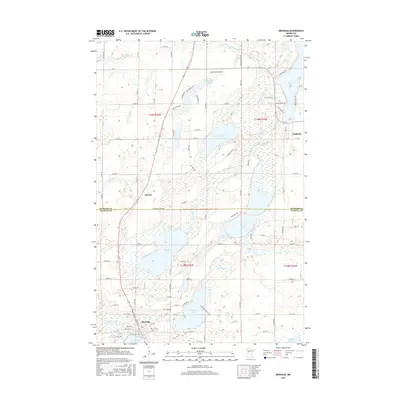
2016 Map of Menahga
USGS Topo · Published 2016About this map
Menahga serves as the primary population center at the southern edge of this region, situated where the Blueberry River flows into Spirit Lake. The landscape is defined by an intricate network of waterways and wetlands, including the extensive course of the Shell River and prominent bodies of water like Blueberry Lake and Hinds Lake. Historically a timber and agricultural area, the map reveals a transition toward lakeside residential development, particularly around Long Lake and Stocking Lake, where newer roads such as Beach Haven Rd and Breezy Pines Dr have been established. Smaller settlements like Horton and the village of Hubbard anchor the outlying rural areas. Evidence of local infrastructure includes the Falk Private Airport and a grid of township roads that provide access to the numerous marshes and creeks feeding into the Straight River and Fishhook River.
Find a feature on this map
84 named features on this map. Tap any name to fly to it.
Don’t see what you’re looking for? This feature index may not catch every label — zoom into the map to look around manually.
Map Details
Editions of this 2016 Menahga Map
This is the sole edition of this map. No revisions or reprints were ever made.
Other maps of this area

1953 · Brainerd
USGS Topo · 1:250,000

1957 · Brainerd
USGS Topo · 1:250,000

1958 · Brainerd
USGS Topo · 1:250,000

1965 · Brainerd
USGS Topo · 1:250,000

1969 · Park Rapids
USGS Topo · 1:24,000

1969 · Menahga
USGS Topo · 1:24,000

1969 · Park Rapids SW
USGS Topo · 1:24,000

1969 · Sebeka
USGS Topo · 1:24,000

1969 · Sebeka NW
USGS Topo · 1:24,000
1969 · Park Rapids NW
USGS Topo · 1:24,000