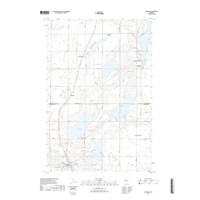
2019 Map of Menahga
USGS Topo · Published 2019About this map
Menahga serves as the primary hub in this lake-rich region on the border of Hubbard and Wadena Counties. The landscape is defined by an intricate network of waterways, including the Blueberry River and Shell River, which connect a series of significant water bodies like Blueberry Lake, Stocking Lake, and Spirit Lake. The distribution of residential roads and small settlements like Horton and Hubbard illustrates the modern development pattern around these glacial lakes, where recreational access and rural homesteads meet. The presence of the Falk Private Airport and numerous local routes such as Blue Heron Trl and Chippewa Loop indicate a community deeply integrated with its natural surroundings. Further north, the Straight River and Fishhook River meander through low-lying areas, highlighting the hydrological complexity of this Minnesota wetland environment during the early 21st century.
Find a feature on this map
86 named features on this map. Tap any name to fly to it.
Don’t see what you’re looking for? This feature index may not catch every label — zoom into the map to look around manually.
Map Details
Editions of this 2019 Menahga Map
This is the sole edition of this map. No revisions or reprints were ever made.
Other maps of this area

1953 · Brainerd
USGS Topo · 1:250,000

1957 · Brainerd
USGS Topo · 1:250,000

1958 · Brainerd
USGS Topo · 1:250,000

1965 · Brainerd
USGS Topo · 1:250,000

1969 · Park Rapids
USGS Topo · 1:24,000

1969 · Menahga
USGS Topo · 1:24,000

1969 · Park Rapids SW
USGS Topo · 1:24,000

1969 · Sebeka
USGS Topo · 1:24,000

1969 · Sebeka NW
USGS Topo · 1:24,000
1969 · Park Rapids NW
USGS Topo · 1:24,000