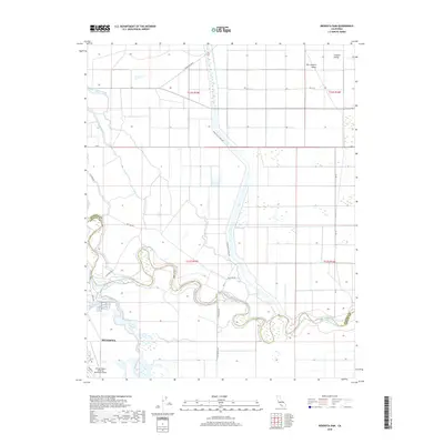
2018 Map of Mendota Dam
USGS Topo · Published 2018About this map
The San Joaquin River snakes through the heart of the Central Valley in this survey of the region surrounding Mendota. This landscape is defined by its complex irrigation and water management systems, essential for the agricultural productivity of the area. Significant water features include the Mendota Pool, where the Fresno Slough meets the river, and numerous man-made channels like the Ridge Ditch and Chowchilla Canal Rd. To the southwest, the William Robert Johnston Municipal Airport serves as a vital infrastructure hub for the local community. The map also records the jurisdictional line of the Madera and Fresno county boundary as it follows the original wandering path of the river, contrasting with the strictly gridded agricultural roads like Ave 7 1/2 and Ave 6 that segment the surrounding plains.
Find a feature on this map
29 named features on this map. Tap any name to fly to it.
Don’t see what you’re looking for? This feature index may not catch every label — zoom into the map to look around manually.
Map Details
Editions of this 2018 Mendota Dam Map
This is the sole edition of this map. No revisions or reprints were ever made.
Other maps of this area

1920 · Bonita Ranch
USGS Topo · 1:31,680

1921 · Mendota
USGS Topo · 1:31,680

1921 · Bonita Ranch
USGS Topo · 1:31,680

1922 · Tufts Ranch
USGS Topo · 1:31,680

1922 · Pozo Farm
USGS Topo · 1:31,680

1922 · Kentucky Well
USGS Topo · 1:31,680

1923 · Firebaugh
USGS Topo · 1:31,680

1924 · Jamesan
USGS Topo · 1:31,680

1924 · Tranquillity
USGS Topo · 1:31,680

1924 · Gravelly Ford
USGS Topo · 1:31,680