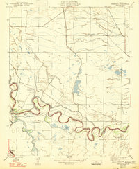
1947 Map of Mendota
USGS Topo · Published 1947About this map
The San Joaquin River snakes with tight meanders through the central San Joaquin Valley, defining the border between Fresno and Madera counties. This landscape, as revised in 1946, is a complex network of hydraulic engineering designed for agriculture, centered on the Mendota Dam. The hydrology of the region is shaped by the intersection of the river with the Chowchilla Canal and Columbia Canal, alongside natural drainage features like Lone Willow Slough and Fresno Slough. Large-scale landholdings are prominent throughout the quadrangle, including the New Columbia Ranch, Pomona Ranch, and Aliso Ranch. These ranching and farming operations relied on the windmills and canals that dot the arid terrain, illustrating the intensive water management required for valley development. In the southwest corner, the town of Mendota serves as a local hub at the junction of rail and road.
Find a feature on this map
17 named features on this map. Tap any name to fly to it.
Don’t see what you’re looking for? This feature index may not catch every label — zoom into the map to look around manually.
Map Details
Editions of this 1947 Mendota Map
This is the sole edition of this map. No revisions or reprints were ever made.
Other maps of this area

1920 · Bonita Ranch
USGS Topo · 1:31,680

1921 · Mendota
USGS Topo · 1:31,680

1921 · Bonita Ranch
USGS Topo · 1:31,680

1922 · Tufts Ranch
USGS Topo · 1:31,680

1922 · Pozo Farm
USGS Topo · 1:31,680

1922 · Kentucky Well
USGS Topo · 1:31,680

1923 · Firebaugh
USGS Topo · 1:31,680

1924 · Jamesan
USGS Topo · 1:31,680

1924 · Tranquillity
USGS Topo · 1:31,680

1924 · Gravelly Ford
USGS Topo · 1:31,680