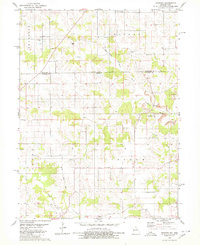
1979 Map of Mendota
USGS Topo · Published 1980About this map
Appanoose and Putnam counties meet along the Iowa-Missouri border in this 1970s landscape, where local life follows the drainages of Shoal Creek and North Blackbird Creek. The settlement of Mendota serves as a focal point, situated near the Mendota Cemetery and the visible scarring of Strip Mines to the east. This area reveals the transition from active rail to historic memory, as the Old Railroad Grade cuts through the township of Pleasant, passing near the Boswell Cemetery. Further south in Lincoln township, the Stringtown Church and the small community of Howland mark the rural intersections. The map provides a detailed view of the terrain before modern consolidation, recording the specific locations of family cemeteries and remote creek forks like Sandy Creek that defined the early boundaries of these border communities.
Find a feature on this map
20 named features on this map. Tap any name to fly to it.
Don’t see what you’re looking for? This feature index may not catch every label — zoom into the map to look around manually.
Map Details
Editions of this 1979 Mendota Map
This is the sole edition of this map. No revisions or reprints were ever made.
Other maps of this area

1912 · Green City
USGS Topo · 1:62,500

1914 · Green City
USGS Topo · 1:62,500

1939 · Centerville
USGS Topo · 1:62,500

1941 · Centerville
USGS Topo · 1:62,500

1942 · Seymour
USGS Topo · 1:62,500

1944 · Seymour
USGS Topo · 1:62,500

1954 · Centerville
USGS Topo · 1:250,000

1957 · Centerville
USGS Topo · 1:250,000

1958 · Centerville
USGS Topo · 1:250,000

1964 · Unionville West
USGS Topo · 1:24,000