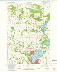
1972 Map of Menomonie North
USGS Topo · Published 1975About this map
Lake Menomin and the Red Cedar River anchor this mid-century topographic survey of the area north of Menomonie. The landscape is defined by the expansion of the Stout State University campus and the industrial corridors created by the Chicago and North Western railroad. Significant residential and academic growth is evident in North Menomonie, while further north, the shoreline of Tainter Lake shows a developing recreational pattern with the Public Access and Powerplant at Cedar Falls.
Find a feature on this map
56 named features on this map. Tap any name to fly to it.
Don’t see what you’re looking for? This feature index may not catch every label — zoom into the map to look around manually.
Map Details
Editions of this 1972 Menomonie North Map
This is the sole edition of this map. No revisions or reprints were ever made.
Other maps of this area

1940 · Menomonie
USGS Topo · 1:62,500

1942 · Menomonie
USGS Topo · 1:62,500

1946 · Knapp
USGS Topo · 1:62,500

1948 · Downing
USGS Topo · 1:62,500

1949 · Knapp
USGS Topo · 1:62,500

1949 · Ridgeland
USGS Topo · 1:62,500

1950 · Downing
USGS Topo · 1:62,500

1951 · Ridgeland
USGS Topo · 1:62,500

1953 · Saint Paul
USGS Topo · 1:250,000

1953 · Eau Claire
USGS Topo · 1:250,000