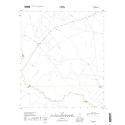
2019 Map of Mentone
USGS Topo · Published 2019About this map
Mentone stands as the primary hub of settlement in this arid West Texas landscape, positioned at the intersection of Ranch Rd 1211 and Pecos St. The town's presence is tied to the critical water resource of the Pecos River, which carves a winding path along the southern boundary of the quadrangle. The river creates a sharp geographic contrast, defining the border between Loving, Ward, and Reeves counties. Significant terrain features like the wide Rudd Draw in the northeast and the prominent loop at Texas Bend illustrate the drainage patterns that dictate the placement of roads and homesteads in this sparse ranching country. Local transport is defined by a network of numbered routes such as Metor Rd and Co Rd 300, which extend from the town center across the undulating basin floor toward neighboring county lines.
Find a feature on this map
19 named features on this map. Tap any name to fly to it.
Don’t see what you’re looking for? This feature index may not catch every label — zoom into the map to look around manually.
Map Details
Editions of this 2019 Mentone Map
This is the sole edition of this map. No revisions or reprints were ever made.
Other maps of this area

1954 · Pecos
USGS Topo · 1:250,000

1957 · Pecos
USGS Topo · 1:250,000

1961 · Soda Lake
USGS Topo · 1:24,000

1961 · Mentone
USGS Topo · 1:24,000

1961 · Anderson Ranch
USGS Topo · 1:24,000

1961 · Lindley Ranch
USGS Topo · 1:24,000

1961 · Sand Lake
USGS Topo · 1:24,000

1967 · Soda Lake NW
USGS Topo · 1:24,000

1968 · Mentone SW
USGS Topo · 1:24,000

1969 · Cheyenne Draw SW
USGS Topo · 1:24,000