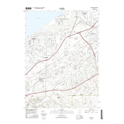
2016 Map of Mentor
USGS Topo · Published 2016About this map
The James A Garfield National Historic Site stands as a central historical anchor in this 2016 survey of the lakefront and inland communities of Lake County. This map documents a dense suburban landscape stretching from the shoreline at Mentor-on-the-Lake and the protected Mentor Marsh through the developed centers of Mentor and Painesville. The transition from the coastal plains of Lake Erie to the more varied terrain of the south is marked by the presence of Little Mountain and The Knob, where the topography rises significantly above the river valleys.
Find a feature on this map
184 named features on this map. Tap any name to fly to it.
Don’t see what you’re looking for? This feature index may not catch every label — zoom into the map to look around manually.
Map Details
Editions of this 2016 Mentor Map
This is the sole edition of this map. No revisions or reprints were ever made.
Other maps of this area

1904 · Chardon
USGS Topo · 1:62,500

1905 · Perry
USGS Topo · 1:62,500

1905 · Mentor
USGS Topo · 1:62,500

1906 · Chardon
USGS Topo · 1:62,500

1907 · Mentor
USGS Topo · 1:62,500

1950 · Cleveland
USGS Topo · 1:250,000

1953 · Chardon
USGS Topo · 1:24,000
1953 · Mayfield Heights
USGS Topo · 1:24,000

1953 · Chesterland
USGS Topo · 1:24,000

1953 · Mentor
USGS Topo · 1:24,000