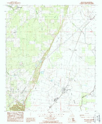
1988 Map of Mer Rouge
USGS Topo · Published 1988About this map
Mer Rouge serves as the focal point of this Morehouse Parish landscape, situated at the edge of the expansive Prairie. The area is defined by a dense network of waterways, including the winding Bayou Bartholomew to the northwest and the smaller Bayou Mer Rouge and Little Bayou Galion that thread through the eastern lowlands. The presence of The Glades and Handy Brake indicates the wet, marshy character of the terrain surrounding the agricultural and residential clusters. Small settlements like Galion and Stampley are mapped alongside local landmarks such as the Landing Strip and multiple Cem sites. These features suggest a community deeply integrated with its drainage patterns and land-use needs in the late 1980s. Traces of the Bastrop Corp Bdy on the western edge further highlight the proximity of the parish seat's expanding footprint during this period.
Find a feature on this map
20 named features on this map. Tap any name to fly to it.
Don’t see what you’re looking for? This feature index may not catch every label — zoom into the map to look around manually.
Map Details
Editions of this 1988 Mer Rouge Map
This is the sole edition of this map. No revisions or reprints were ever made.
Other maps of this area

1935 · Collinston
USGS Topo · 1:62,500

1935 · Naff
USGS Topo · 1:62,500

1935 · Hurricane
USGS Topo · 1:62,500

1935 · Bonita
USGS Topo · 1:62,500

1955 · Jackson
USGS Topo · 1:250,000

1956 · Bastrop
USGS Topo · 1:62,500

1957 · Collinston
USGS Topo · 1:62,500

1958 · Hurricane
USGS Topo · 1:62,500

1958 · Bonita
USGS Topo · 1:62,500

1961 · Jackson
USGS Topo · 1:250,000