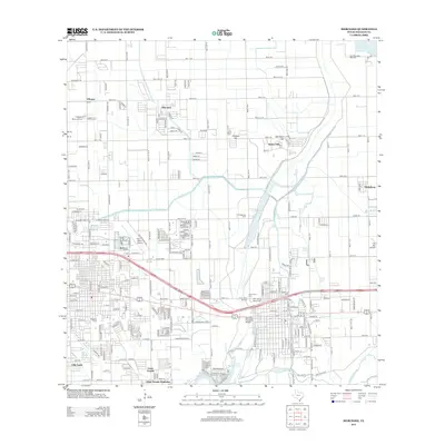
2013 Map of Mercedes
USGS Topo · Published 2013About this map
Mercedes and its surrounding communities in Hidalgo County reveal a landscape defined by an extensive grid of agricultural and residential development in the Rio Grande Valley. The Arroyo Colorado and Llano Grande Lake anchor the southern reaches of the map, while the northern sections are bisected by an orderly network of roads such as Mile 13 N and Mile 12 N. The region's industrial and logistical importance is noted by the Lacy-Mercedes Gas Field and the Mid Valley Airport. Community institutions and historical resting places are prominent throughout the area, including Weslaco Cem, Our Lady of Mercy Cem, and Highland Memorial Cem. Smaller residential clusters like Heidelberg, Mila Doce, and Indian Hills are integrated into this dense agricultural tapestry, reflecting the area's steady growth and settlement patterns in the early 21st century.
Find a feature on this map
49 named features on this map. Tap any name to fly to it.
Don’t see what you’re looking for? This feature index may not catch every label — zoom into the map to look around manually.
Map Details
Editions of this 2013 Mercedes Map
This is the sole edition of this map. No revisions or reprints were ever made.
Other maps of this area

1914 · San Juan
USGS Topo · 1:48,000

1916 · San Juan
USGS Topo · 1:62,500

1929 · Santa Rosa
USGS Topo · 1:24,000

1929 · Santa Maria
USGS Topo · 1:24,000

1929 · La Feria
USGS Topo · 1:24,000

1933 · Santa Rosa
USGS Topo · 1:31,680

1936 · La Feria
USGS Topo · 1:31,680

1936 · Santa Maria
USGS Topo · 1:31,680

1949 · Mc Allen
USGS Topo · 1:250,000

1953 · Brownsville
USGS Topo · 1:250,000
Featured Places
- Weslaco, TX
- Mercedes, TX
- Olivarez Number 2 Colonia, TX
- Southern Valley Estates Colonia, TX
- Olivarez Number 10 Colonia, TX