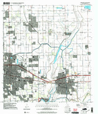
2002 Map of Mercedes
USGS Topo · Published 2003About this map
Weslaco and Mercedes anchor this study of the Rio Grande Valley, where a dense network of drainage ditches and floodways manages the flat, agricultural terrain. The landscape is defined by the intersection of traditional citrus and vegetable farming infrastructure with growing residential areas like Sunrise Hill and Heidelberg. Irrigation systems feeding off the Arroyo Colorado and Campacuas Lake dictate the layout of the land, while the presence of the Lacy-Mercedes gas field to the northeast points to the region's energy resources.
Find a feature on this map
50 named features on this map. Tap any name to fly to it.
Don’t see what you’re looking for? This feature index may not catch every label — zoom into the map to look around manually.
Map Details
Editions of this 2002 Mercedes Map
This is the sole edition of this map. No revisions or reprints were ever made.
Other maps of this area

1914 · San Juan
USGS Topo · 1:48,000

1916 · San Juan
USGS Topo · 1:62,500

1929 · Santa Rosa
USGS Topo · 1:24,000

1929 · Santa Maria
USGS Topo · 1:24,000

1929 · La Feria
USGS Topo · 1:24,000

1933 · Santa Rosa
USGS Topo · 1:31,680

1936 · La Feria
USGS Topo · 1:31,680

1936 · Santa Maria
USGS Topo · 1:31,680

1949 · Mc Allen
USGS Topo · 1:250,000

1953 · Brownsville
USGS Topo · 1:250,000
Featured Places
- Weslaco, TX
- Mercedes, TX
- Elizabeth Colonia, TX
- Cuellar Colonia Number 1, TX
- Highland Memorial Park Colonia, TX