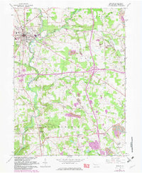
1961 Map of Mercer
USGS Topo · Published 1982About this map
Mercer serves as the focal point of this regional study, showing a developed street grid complete with a State Sanitorium, Hospital, and local Fairgrounds. The surrounding landscape of Findley and Springfield townships is defined by a transition from traditional agriculture and small settlements like Pardoe and Millburn to an industrial extractive economy. Numerous Strip Mines and a Tipple are marked throughout the central and eastern portions of the quadrangle, indicating the intensity of coal operations during the mid-20th century. Historical preservation is evident at the Johnston Tavern Historical Site near Springfield Falls, while transportation infrastructure is represented by a growing interchange and the Grove City Airport. Waterways like Neshannock Creek and Cool Spring Creek provide the drainage for this active industrial and residential corridor.
Find a feature on this map
64 named features on this map. Tap any name to fly to it.
Don’t see what you’re looking for? This feature index may not catch every label — zoom into the map to look around manually.
Map Details
Editions of this 1961 Mercer Map
4 editions found
Other maps of this area

1905 · Neshannock
USGS Topo · 1:62,500

1907 · Neshannock
USGS Topo · 1:62,500

1908 · Shenango
USGS Topo · 1:62,500

1911 · Stoneboro
USGS Topo · 1:62,500

1913 · Stoneboro
USGS Topo · 1:62,500

1913 · Mercer
USGS Topo · 1:62,500

1939 · Mercer
USGS Topo · 1:62,500

1943 · Mercer
USGS Topo · 1:62,500

1943 · Stoneboro
USGS Topo · 1:62,500

1950 · Cleveland
USGS Topo · 1:250,000
Featured Places
- Mercer, PA
- Findley Township, PA
- East Lackawannock Township, PA
- Amsterdam, Liberty Township
- Wolf Creek Township, PA