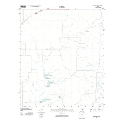
2010 Map of Mercers Gap
USGS Topo · Published 2010About this map
Watson stands as a primary point of reference in this rural Comanche County landscape, situated near the headwaters of several drainage systems. The terrain is defined by natural low points and crossings, notably Mercers Gap and Cox Gap, which likely dictated the historic movement of people and livestock through these hills. This 2010 survey illustrates a landscape heavily modified for water management and soil preservation, characterized by an extensive network of infrastructure such as the Soil Conservation Service Site 12 Reservoir and the Willis Lake Dam. These reservoirs, including those along Dry Blanket Creek, reflect twentieth-century efforts to stabilize the watershed and support agriculture. The southern edge of the quadrangle reaches the South Leon River, while Mercer Creek flows toward Lake Eanes in the northeast, anchoring a network of county roads that connect remote homesteads and ranch lands.
Find a feature on this map
36 named features on this map. Tap any name to fly to it.
Don’t see what you’re looking for? This feature index may not catch every label — zoom into the map to look around manually.
Map Details
Editions of this 2010 Mercers Gap Map
This is the sole edition of this map. No revisions or reprints were ever made.
Other maps of this area

1889 · Brownwood
USGS Topo · 1:125,000

1894 · Brownwood
USGS Topo · 1:125,000

1928 · Zephyr
USGS Topo · 1:62,500

1931 · Mullin
USGS Topo · 1:62,500

1950 · Zephyr
USGS Topo · 1:62,500

1950 · Mullin
USGS Topo · 1:62,500

1954 · Brownwood
USGS Topo · 1:250,000

1966 · Star Mountain
USGS Topo · 1:24,000
1966 · Blanket
USGS Topo · 1:24,000
1969 · Sidney
USGS Topo · 1:24,000