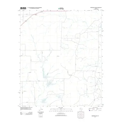
2012 Map of Mercers Gap
USGS Topo · Published 2012About this map
Watson stands at the northern edge of this Central Texas landscape, where the prairie begins to break into the subtle rises and dips of the Texas Hill Country periphery. The geography is defined by narrow passes like Cox Gap and Mercers Gap, which historically dictated the flow of travel through this rural section of Comanche County. A network of county roads, including Co RD-145 and Co RD-207, connects isolated farmsteads across a terrain drained by Mercer Cr and Dry Blanket Cr. The map reveals a twentieth-century layer of water management, visible in the string of reservoirs such as Soil Conservation Service Site 14 Reservoir and Soil Conservation Service Site 12 Reservoir. These features, along with Lake Eanes, illustrate the region's adaptation to the semi-arid climate, securing water for the ranching and agricultural operations that reach south toward the S Leon River.
Find a feature on this map
37 named features on this map. Tap any name to fly to it.
Don’t see what you’re looking for? This feature index may not catch every label — zoom into the map to look around manually.
Map Details
Editions of this 2012 Mercers Gap Map
This is the sole edition of this map. No revisions or reprints were ever made.
Other maps of this area

1889 · Brownwood
USGS Topo · 1:125,000

1894 · Brownwood
USGS Topo · 1:125,000

1928 · Zephyr
USGS Topo · 1:62,500

1931 · Mullin
USGS Topo · 1:62,500

1950 · Zephyr
USGS Topo · 1:62,500

1950 · Mullin
USGS Topo · 1:62,500

1954 · Brownwood
USGS Topo · 1:250,000

1966 · Star Mountain
USGS Topo · 1:24,000
1966 · Blanket
USGS Topo · 1:24,000
1969 · Sidney
USGS Topo · 1:24,000