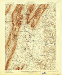
1902 Map of Mercersburg
USGS Topo · Published 1931About this map
The dramatic ridge-and-valley province of south-central Pennsylvania dominates this 1900 survey, where the massive wall of Tuscarora Mountain and Cove Mountain funnel settlement into the fertile lowlands. The industrial roots of the region are evident at Richmond Furnace and Franklin Furnace, marking the early iron industry that thrived near the mountain ore banks. In the valley below, the Southern Pennsylvania Br railroad links established agricultural and commercial hubs like Mercersburg and Fort Loudon.
Find a feature on this map
69 named features on this map. Tap any name to fly to it.
Don’t see what you’re looking for? This feature index may not catch every label — zoom into the map to look around manually.
Map Details
Editions of this 1902 Mercersburg Map
5 editions found
Other maps of this area

1899 · Hancock
USGS Topo · 1:62,500

1900 · Mercersburg
USGS Topo · 1:62,500

1901 · Hancock
USGS Topo · 1:62,500

1902 · Chambersburg
USGS Topo · 1:62,500

1902 · Mercersburg
USGS Topo · 1:62,500

1909 · Hagerstown
USGS Topo · 1:48,000

1912 · Hagerstown
USGS Topo · 1:62,500

1912 · Williamsport
USGS Topo · 1:62,500

1923 · Shippensburg
USGS Topo · 1:62,500

1925 · Needmore
USGS Topo · 1:48,000