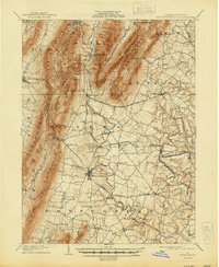
1902 Map of Mercersburg
USGS Topo · Published 1944About this map
The Cumberland Valley RR and Southern Pennsylvania Br define the valley floors of this 1900 survey, connecting small industrial hamlets like Richmond Furnace and Franklin Furnace to the larger centers of Mercersburg and Mcconnellsburg. The landscape is dominated by the parallel ridges of Tuscarora Mountain and Cove Mountain, which isolate Path Valley and Bear Valley from the broader agricultural expanses to the east.
Find a feature on this map
79 named features on this map. Tap any name to fly to it.
Don’t see what you’re looking for? This feature index may not catch every label — zoom into the map to look around manually.
Map Details
Editions of this 1902 Mercersburg Map
5 editions found
Other maps of this area

1899 · Hancock
USGS Topo · 1:62,500

1900 · Mercersburg
USGS Topo · 1:62,500

1901 · Hancock
USGS Topo · 1:62,500

1902 · Chambersburg
USGS Topo · 1:62,500

1902 · Mercersburg
USGS Topo · 1:62,500

1909 · Hagerstown
USGS Topo · 1:48,000

1912 · Hagerstown
USGS Topo · 1:62,500

1912 · Williamsport
USGS Topo · 1:62,500

1923 · Shippensburg
USGS Topo · 1:62,500

1925 · Needmore
USGS Topo · 1:48,000