
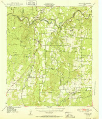
1950 Map of Mercury
USGS Topo · Published 1950About this map
The Colorado River winds through the heart of this Central Texas landscape, marking the jagged boundaries between Coleman, Brown, McCulloch, and San Saba counties. This mid-century survey captures a rural ranching and farming economy defined by small, dispersed settlements like Mercury, Placid, and Winchell. The land is punctuated by distinctive topographical landmarks, such as the prominent High Lonesome and Pack Saddle Hill, which rise above the surrounding creek drainages.
Find a feature on this map
47 named features on this map. Tap any name to fly to it.
Don’t see what you’re looking for? This feature index may not catch every label — zoom into the map to look around manually.
Map Details
Editions of this 1950 Mercury Map
2 editions found
Other maps of this area

1885 · San Saba
USGS Topo · 1:125,000

1887 · Coleman
USGS Topo · 1:125,000

1889 · Brownwood
USGS Topo · 1:125,000

1889 · Coleman
USGS Topo · 1:125,000

1894 · Brady
USGS Topo · 1:125,000

1894 · Brownwood
USGS Topo · 1:125,000

1894 · San Saba
USGS Topo · 1:125,000

1924 · Brady 2-a
USGS Topo · 1:48,000

1925 · Brady 1-b
USGS Topo · 1:48,000

1925 · Brady 1-a
USGS Topo · 1:48,000