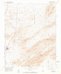
1961 Map of Mercury
USGS Topo · Published 1962About this map
The town of Mercury and the high-security infrastructure of the Cold War era define this 1961 desert survey. Established as a base camp for the Nevada Test Site, the settlement is shown here with its proximity to the Mercury Highway and critical support facilities like Desert Rock Park. The map documents a landscape of specialized utility, marked by a series of infrastructure nodes such as Pumping Station 2, Pumping Station 3, and Pumping Station 4 that sustained operations in this arid environment.
Find a feature on this map
35 named features on this map. Tap any name to fly to it.
Don’t see what you’re looking for? This feature index may not catch every label — zoom into the map to look around manually.
Map Details
Editions of this 1961 Mercury Map
3 editions found
Other maps of this area

1907 · Las Vegas
USGS Topo · 1:250,000

1908 · Furnace Creek
USGS Topo · 1:250,000

1908 · Las Vegas
USGS Topo · 1:250,000

1910 · Furnace Creek
USGS Topo · 1:250,000

1942 · Indian Spring
USGS Topo · 1:125,000

1942 · Skull Mountain
USGS Topo · 1:125,000

1948 · Death Valley
USGS Topo · 1:250,000

1952 · Specter Range
USGS Topo · 1:62,500

1952 · Mercury
USGS Topo · 1:62,500
1952 · Frenchman Lake
USGS Topo · 1:62,500