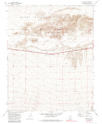
1973 Map of Mercury SE
USGS Topo · Published 1985About this map
The Indian Springs Valley floor and the surrounding high desert terrain dominate this mid-century survey of Clark County. The landscape is defined by its administrative and environmental designations, split between the Desert National Wildlife Range and the restricted southern edge of the Nellis Air Force Range. These boundaries intersect near a notable geological Depression, where the map documents a series of industrial and exploratory markers including Borrow Pits and a Drill Hole. Along the southern margin, Willow Creek provides a rare riparian trace in an otherwise arid environment. This 1970s record, photoinspected in the early 1980s, captures the region before significant expansion, showing the primary transit route of Highway 95 as it cuts across the open valley basin.
Find a feature on this map
11 named features on this map. Tap any name to fly to it.
Don’t see what you’re looking for? This feature index may not catch every label — zoom into the map to look around manually.
Map Details
Editions of this 1973 Mercury SE Map
2 editions found
Other maps of this area

1907 · Las Vegas
USGS Topo · 1:250,000

1908 · Las Vegas
USGS Topo · 1:250,000

1942 · Indian Spring
USGS Topo · 1:125,000

1952 · Mercury
USGS Topo · 1:62,500

1954 · Las Vegas
USGS Topo · 1:250,000

1957 · Las Vegas
USGS Topo · 1:250,000

1957 · Mt. Stirling
USGS Topo · 1:62,500

1957 · Charleston Peak
USGS Topo · 1:62,500

1959 · Las Vegas
USGS Topo · 1:250,000
1961 · Mercury
USGS Topo · 1:24,000