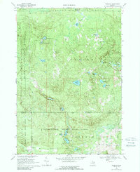
1969 Map of Meredith
USGS Topo · Published 1989About this map
Meredith stands at the southern edge of this Michigan survey, where the borders of Roscommon, Gladwin, and Clare counties converge. The landscape is dominated by the dense woodlands of the Houghton Lake State Forest and the Tittabawassee River State Forest, a terrain defined by glacial depressions that have formed a complex network of small lakes and marshes.
Find a feature on this map
38 named features on this map. Tap any name to fly to it.
Don’t see what you’re looking for? This feature index may not catch every label — zoom into the map to look around manually.
Map Details
Editions of this 1969 Meredith Map
2 editions found
Other maps of this area

1954 · Traverse City
USGS Topo · 1:250,000

1958 · Traverse City
USGS Topo · 1:250,000

1963 · Backus Lake
USGS Topo · 1:24,000

1963 · Prudenville
USGS Topo · 1:24,000

1965 · St. Helen
USGS Topo · 1:24,000

1969 · Meredith NW
USGS Topo · 1:24,000

1969 · Meredith
USGS Topo · 1:24,000

1969 · Butman
USGS Topo · 1:24,000

1969 · Wagarville
USGS Topo · 1:24,000

1969 · Meredith SW
USGS Topo · 1:24,000