
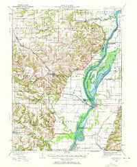
1928 Map of Meredosia
USGS Topo · Published 1958About this map
The Illinois River valley dominates this late 1920s landscape, serving as a complex corridor for river navigation, drainage, and rail transport. The river's influence is evident in the extensive wetlands and backwaters like Meredosia Lake and Elbow Lake, which are bordered by significant infrastructure including the La Grange Locks and the South Beardstown Pumping Station. In the uplands of Mt Sterling and Versailles, a dense network of country schools like Howe Sch, Hill Sch, and Vandeventer Sch served the rural population.
Find a feature on this map
95 named features on this map. Tap any name to fly to it.
Don’t see what you’re looking for? This feature index may not catch every label — zoom into the map to look around manually.
Map Details
Editions of this 1928 Meredosia Map
2 editions found
Other maps of this area

1923 · Rushville
USGS Topo · 1:62,500

1924 · Winchester
USGS Topo · 1:48,000

1924 · Griggsville
USGS Topo · 1:62,500

1926 · Griggsville
USGS Topo · 1:62,500

1926 · Beardstown
USGS Topo · 1:62,500

1926 · Pittsfield
USGS Topo · 1:62,500

1926 · Winchester
USGS Topo · 1:62,500

1926 · Rushville
USGS Topo · 1:62,500

1926 · Mt Sterling
USGS Topo · 1:62,500

1929 · Mt Sterling
USGS Topo · 1:62,500