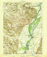
1931 Map of Meredosia
USGS Topo · Published 1931About this map
The Illinois River serves as the central artery of this 1931 survey, shaping the local economy and geography of the river towns. At Meredosia, the Wabash RR crosses the waterway, while the La Grange Locks and South Beardstown Pumping Station indicate the intensive hydraulic engineering of the era. The floodplain is a complex network of backwaters like Meredosia Lake and Barlow Lake, contrasting with the higher bluffs to the west where towns like Versailles and Chambersburg sit.
Find a feature on this map
75 named features on this map. Tap any name to fly to it.
Don’t see what you’re looking for? This feature index may not catch every label — zoom into the map to look around manually.
Map Details
Editions of this 1931 Meredosia Map
2 editions found

Other maps of this area

1923 · Rushville
USGS Topo · 1:62,500

1924 · Winchester
USGS Topo · 1:48,000

1924 · Griggsville
USGS Topo · 1:62,500

1926 · Griggsville
USGS Topo · 1:62,500

1926 · Beardstown
USGS Topo · 1:62,500

1926 · Pittsfield
USGS Topo · 1:62,500

1926 · Winchester
USGS Topo · 1:62,500

1926 · Rushville
USGS Topo · 1:62,500

1926 · Mt Sterling
USGS Topo · 1:62,500

1928 · Meredosia
USGS Topo · 1:62,500