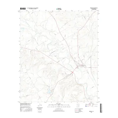
2016 Map of Meridian
USGS Topo · Published 2016About this map
The North Bosque River winds through this central Texas landscape, anchoring the settlement of Meridian. This 2016 survey illustrates the convergence of local infrastructure and natural waterways, where the river meets a network of state and county roads like St Park Rd 7 and Farm Rd 1473. The town's grid is clearly defined, showing its proximity to the water's path and the surrounding hills. To the south and west, the topography is punctuated by distinct water bodies including Meridian Lake and B E Farrell Lake Number 2. Small tributaries such as Bee Cr, Gibson Br, and Dyes Br reveal the drainage patterns that define the local terrain. The inclusion of Twin Mtn Rd in the southeast corner provides a reference point for the higher elevations that overlook the river valley.
Find a feature on this map
56 named features on this map. Tap any name to fly to it.
Don’t see what you’re looking for? This feature index may not catch every label — zoom into the map to look around manually.
Map Details
Editions of this 2016 Meridian Map
This is the sole edition of this map. No revisions or reprints were ever made.
Other maps of this area

1888 · Meridian
USGS Topo · 1:125,000

1889 · Granbury
USGS Topo · 1:125,000

1894 · Meridian
USGS Topo · 1:125,000

1931 · Morgan
USGS Topo · 1:62,500

1954 · Dallas
USGS Topo · 1:250,000

1954 · Waco
USGS Topo · 1:250,000

1955 · Waco
USGS Topo · 1:250,000

1955 · Clifton
USGS Topo · 1:24,000

1955 · Meridian
USGS Topo · 1:24,000
1955 · Pilot Knob
USGS Topo · 1:24,000