
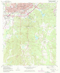
1971 Map of Meridian South
USGS Topo · Published 1973About this map
Meridian anchor's this 1970s landscape, where the urban grid of the city meets the wooded ridges of eastern Mississippi. The map documents a significant era of infrastructure, showing the expansion of residential neighborhoods like Oakland Heights and Savannah Grove alongside the developing campus of Meridian Jr College. Transportation and industry are prominent features, from the operations at Key Field to the Southern and Gulf Mobile And Ohio rail lines. The city's edge transitions into a network of small communities such as Bonita and Zero, where life centered around landmarks like the Long Creek Recreation Center and numerous local churches including Jones Chapel and Wesley Chapel. Genealogists will find a detailed record of local burials, with locations for Rose Hill Cem, Simpson Cem, and Pine Grove Cem clearly identified among the rolling terrain and numerous sandpits that dot the countryside.
Find a feature on this map
67 named features on this map. Tap any name to fly to it.
Don’t see what you’re looking for? This feature index may not catch every label — zoom into the map to look around manually.
Map Details
Editions of this 1971 Meridian South Map
2 editions found
Other maps of this area

1921 · Meridian
USGS Topo · 1:48,000

1923 · Meridian
USGS Topo · 1:62,500

1953 · Meridian
USGS Topo · 1:250,000

1957 · Meridian
USGS Topo · 1:250,000

1957 · Chunky
USGS Topo · 1:62,500

1957 · Quitman
USGS Topo · 1:62,500

1957 · Enterprise
USGS Topo · 1:62,500

1965 · Meridian
USGS Topo · 1:250,000

1971 · Vimville
USGS Topo · 1:24,000

1971 · Meridian North
USGS Topo · 1:24,000