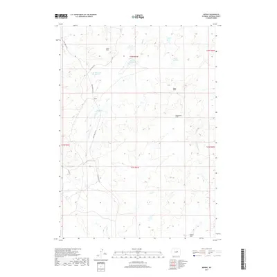
2017 Map of Merino
USGS Topo · Published 2017About this map
The high plains of Natrona County are defined here by a series of intermittent drainages and water management features centered on the small settlement of Merino. This 2017 survey shows an arid landscape where life and ranching revolve around named draws and small catchment basins. Notable water sources include North Thirtythree Mile Reservoir and Thirtythree Mile Reservoir, which capture runoff from the surrounding hills. The terrain is deeply etched by features like Austin Draw and Bayer Draw, illustrating the complex natural irrigation of the Wyoming basin. Local transportation is represented by rural corridors such as Thirtythree Mile Rd and Long Canyon Rd, which provide access to remote areas like Bayer Reservoir and Paul Reservoir. These roads often follow the contours of the land, connecting isolated points across the vast township and range system.
Find a feature on this map
19 named features on this map. Tap any name to fly to it.
Don’t see what you’re looking for? This feature index may not catch every label — zoom into the map to look around manually.
Map Details
Editions of this 2017 Merino Map
This is the sole edition of this map. No revisions or reprints were ever made.
Other maps of this area

1955 · Arminto
USGS Topo · 1:250,000

1958 · Arminto
USGS Topo · 1:250,000

1962 · Arminto
USGS Topo · 1:250,000

1968 · Big Gulch
USGS Topo · 1:24,000

1968 · Merino
USGS Topo · 1:24,000

1968 · Illco
USGS Topo · 1:24,000
1968 · Statzer Point
USGS Topo · 1:24,000

1968 · Camel Hump Reservoir
USGS Topo · 1:24,000

1968 · Reynolds Reservoir
USGS Topo · 1:24,000

1968 · Fiftymile Flat
USGS Topo · 1:24,000