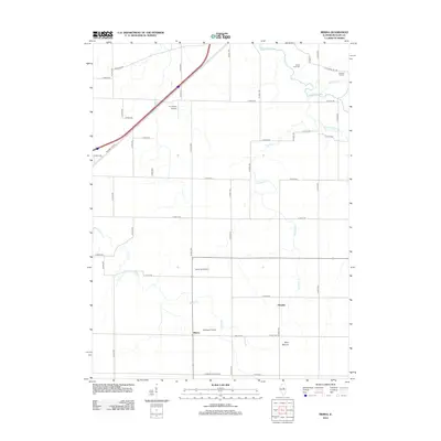
2012 Map of Merna
USGS Topo · Published 2012About this map
The Mackinaw River winds through the northern landscape of McLean County, defining the rural character of this central Illinois terrain. The settlement of Merna serves as a local anchor, accompanied by the smaller hamlet of Fletcher to the east. Agriculture and transportation dominate the map, with the iconic path of Historic Hwy 66 cutting diagonally across the northwest corner alongside Co Hwy-65. This corridor represents the evolution of American travel, preserved here among a grid of county roads that connect remote farmsteads and small private landing strips like P.J. Killian Airport and Schlosser Airport.
Find a feature on this map
49 named features on this map. Tap any name to fly to it.
Don’t see what you’re looking for? This feature index may not catch every label — zoom into the map to look around manually.
Map Details
Editions of this 2012 Merna Map
This is the sole edition of this map. No revisions or reprints were ever made.
Other maps of this area

1926 · Normal
USGS Topo · 1:62,500

1930 · Normal
USGS Topo · 1:62,500

1951 · Le Roy
USGS Topo · 1:62,500

1952 · Arrowsmith
USGS Topo · 1:62,500

1957 · Colfax
USGS Topo · 1:62,500

1958 · Peoria
USGS Topo · 1:250,000

1961 · Peoria
USGS Topo · 1:250,000

1963 · Peoria
USGS Topo · 1:250,000
1981 · Holder
USGS Topo · 1:24,000

1981 · Lexington
USGS Topo · 1:24,000