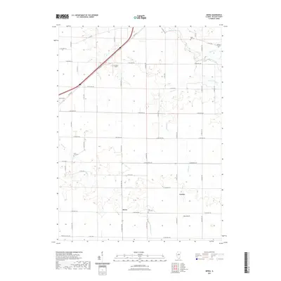
2021 Map of Merna
USGS Topo · Published 2021About this map
Merna and Fletcher anchor this central Illinois landscape, where the agricultural grid is bisected by the iconic alignment of Old Rte 66. The terrain is defined by the gentle drainage of the Mackinaw River in the northeast and the intermittent flow of Money Creek and Crooked Creek. For genealogists and local historians, several burial sites are preserved within these sections, including Holy Cross Cemetery, Smith Grove Cemetery, and the Indian Field Cemetery near the northern boundary. The presence of P J Killian Airport and Blue Mound provide distinct landmarks among the rural road network. The map illustrates a contemporary view of McLean County land use, maintaining a balance between traditional farmstead locations and modern infrastructure like General Electric Road.
Find a feature on this map
31 named features on this map. Tap any name to fly to it.
Don’t see what you’re looking for? This feature index may not catch every label — zoom into the map to look around manually.
Map Details
Editions of this 2021 Merna Map
This is the sole edition of this map. No revisions or reprints were ever made.
Other maps of this area

1926 · Normal
USGS Topo · 1:62,500

1930 · Normal
USGS Topo · 1:62,500

1951 · Le Roy
USGS Topo · 1:62,500

1952 · Arrowsmith
USGS Topo · 1:62,500

1957 · Colfax
USGS Topo · 1:62,500

1958 · Peoria
USGS Topo · 1:250,000

1961 · Peoria
USGS Topo · 1:250,000

1963 · Peoria
USGS Topo · 1:250,000
1981 · Holder
USGS Topo · 1:24,000

1981 · Lexington
USGS Topo · 1:24,000