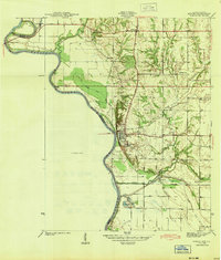
1943 Map of Merom
USGS Topo · Published 1943About this map
The Wabash River serves as the winding boundary between Indiana and Illinois in this 1941 survey, where the river's dynamic path is marked by features like the Hutsonville Cutoff and the Hutsonville Bridge. On the Indiana side, the town of Merom sits atop the bluff, home to the notable Merom Institute. The landscape is a mix of agricultural bottomlands and dissected uplands, with the Illinois Central railroad cutting across the southern portion near Merom Sta and Riverton.
Find a feature on this map
26 named features on this map. Tap any name to fly to it.
Don’t see what you’re looking for? This feature index may not catch every label — zoom into the map to look around manually.
Map Details
Editions of this 1943 Merom Map
2 editions found
Other maps of this area

1917 · Birds
USGS Topo · 1:62,500

1942 · Fairbanks
USGS Topo · 1:24,000

1942 · Shelburn
USGS Topo · 1:24,000

1942 · Birds
USGS Topo · 1:62,500

1943 · Merom
USGS Topo · 1:24,000

1943 · Carlisle
USGS Topo · 1:24,000

1943 · Sullivan
USGS Topo · 1:24,000

1952 · Fairbanks
USGS Topo · 1:24,000

1952 · Shelburn
USGS Topo · 1:24,000

1953 · Indianapolis
USGS Topo · 1:250,000