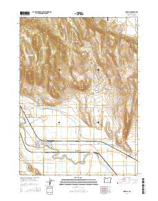
2014 Map of Merrill
USGS Topo · Published 2014About this map
The town of Merrill serves as the hub of this agricultural landscape in Klamath County, situated just north of the California border. The map illustrates a complex water management system essential to the region's productivity, featuring the winding Lost River and a network of irrigation channels including the Van Brimmer Canal, G-Three Canal, and the J Canal. To the north, the terrain rises sharply toward Stukel Mtn and Van Meter Flat, while the valley floor is dotted with reservoirs like Hill-Johnson Reservoir and Hill Reservoir Number One. Local history is anchored by the Merrill IOOF Cem and small settlements like Malone and Stone Bridge. The presence of the Sky Wagon Ranch Airport and landmarks like Adams Point and Whitney Bridge reflect the area's mix of rural infrastructure and natural features, such as the Anderson-Rose Pool and the High Rim overlooking the basin.
Find a feature on this map
79 named features on this map. Tap any name to fly to it.
Don’t see what you’re looking for? This feature index may not catch every label — zoom into the map to look around manually.
Map Details
Editions of this 2014 Merrill Map
This is the sole edition of this map. No revisions or reprints were ever made.
Other maps of this area

1886 · Modoc Lava Bed
USGS Topo · 1:250,000

1889 · Klamath
USGS Topo · 1:250,000

1892 · Modoc Lava-Bed
USGS Topo · 1:250,000

1894 · Klamath
USGS Topo · 1:250,000

1950 · Mt. Dome
USGS Topo · 1:62,500

1951 · Tulelake
USGS Topo · 1:62,500

1954 · Alturas
USGS Topo · 1:250,000

1955 · Klamath Falls
USGS Topo · 1:250,000

1957 · Merrill
USGS Topo · 1:62,500

1957 · Malin
USGS Topo · 1:62,500